
Mount Baker with the Easton Glacier being on the left skyline, below the Black Buttes

Mike, Ryan, and Andy on their alpine start push for the summit

Peter Mullen

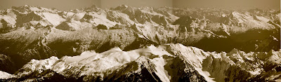
Northern Pickets

Southern Pickets, Jack Mountain, Blum

Despair beyond Hagen

Triumph behind Hagen

Snowfield group


Eldorado and co.

Johannesburg and Hidden Lake Peaks

Whitehorse and the Three Fingers

Southern Pickets


White Chuck, Pugh, Stuart way back, Sloan right

Black Butte (makes me think of a good porter)


The Twin Sisters Range

The Twin Sisters


South Twin Sister

North Twin Sister

Sulphuric gas emitting from the crater, kind of cool


Peter with the Deming Glacier below

The Northern Picket Range: Easy Ridge, Whatcom, Perfect Pass, and Challenger

Northern Picket Range: Mount Challenger, Crooked Thumb Peak, and Mount Fury

Northern Pickets left, Crowder center front, Elephant Butte center back, Southern Pickets right

The Southern Picket Range (Crescent Creek Spires, Mount Terror, Inspiration Peak, Degenhardt, McMillan Spires, Terror Glacier, with Jack Mountain beyond

Southern Picketts with Jack beyond left, and Robinson back right

Mount Blum foreground left, Despair midground right, Davis midground center, Mt. Ballard background center

Hagen Mountain center foreground, Triumph mid right, Pyramid and Pinnacle mid/back/right, Azurite back left, Golden Horn back right, Tower Mountain far back right

In middle-ground: the Pyramid, Pinnacle Peak, Paul Bunyan's Stump, Colonial Peak, the Horseman, The Needle, Snowfield, Neve Glacier
Mid foreground: Triumph and Thorton
Foreground: southern part of Blum
Bckground: Golden Horn, Tower, Silverstar
Mid foreground
Foreground
Bckground: Golden Horn, Tower, Silverstar


Canadia

Chilliwacks: Custer, Redoubt, Spickard, Mox Peaks, Bear

Shuksan summit with Hozomeen behind, dressed in black

See the skin track and 3 skiers on Hell's highway?

How 'bout now?

Glacier Peak

Canadia

Canadia

Peter approaching the summit

And getting into serious trouble with Uncle Sam

Repeatedly


We decided to run for cover

7,700 feet below to the car


Peter coming down the first pitch, 1,200 feet of nice cream.
Only another 6,500 feet to go.
Finally, we had a big weather window synchronized with low avalanche danger. Originally, the forecasters called for clear skies from Thursday to Tuesday, enough time for 2 big boys. Maybe Baker, then Rainier. I checked other websites and saw the same predictions. We've hit the mother window of the winter! Clear skies, no wind, and low avy! I called every ski partner I had, trying to secure a trip to Baker on Friday. But then the forecasts started shrinking the window. By Sunday the clouds would be back, and Thursday and Friday didn't look great either. So Peter Mullen and I were set for Saturday.
We left Seattle Friday night and drove to the end of the road before setting up camp: he in the back of the Prius, me on the truck bed of some semi up there. During the night, some snowmobilers came over to take a piss by the truck and were shocked to see me sleeping there. For the next couple of hours, they drove up and down the road on a four-wheeler, enebriated and whizzing snowballs at me, hitting me once, and driving up my intolerance for rednecks. By midnight, we had peace and quiet and I slept well.
Peter and I woke up at 5:30, got ready and had a bite to eat before skinning down the road a mile to the John Paul Scott trail. The running theme of the day was that nothing looked big but everything was way bigger than that. It took a couple hours of skinning to get out in the open. Then, the summit didn't look that far away. Seeing Mike, Andy and Ryan halfway up, I thought we could catch them. It took them an hour to go up that one slope, which looked small. We could reach them in a couple hours. Nope, it took a couple hours to get to a spot before that. I couldn't believe how slow this was going. Am I skinning slower? I do have a heavier pack. Still, it feels like the normal pace. It was like a time warp. 2,000 vert looked like 500 feet.
But then you get close to the top and look down the 5 miles of fall line skiing you have below, and it looks like you've covered some ground. Then you see Shuksan below, looking small for the first time in your life, and it makes more sense. Then you start skiing it. You stop every thousand feet because your legs are so tired. And you do this a lot! And think This is the longest run of my life!
And the snow was great the whole way down. From top to bottom. 7,700 feet of downhill. Hard to beat. But Mount Rainier is just a couple hours away. Next high pressure/low avy, that'll be the end-all mountain. The descent of descents. We'll ski that thing from summit to bridge, 2 Skillets worth, almost 12,000 feet of skiing. We'll be so tired we'll just cross the bare creek at the bottom with our skis on, and pass out on the highway. That's the biggest fish on my mind. And I think I can really relax after that.

No comments:
Post a Comment